Comey Avenue Continued
"In the hood"? I don't even know what that means but by guessing I assume it means in the neighborhood adjacent to the street called Comey Avenue! Since I spent most of my formative time on Comey Avenue or in the neighborhood, the collection may be a little large and certainly chocked full of trivia and miscellaneous items of no interest to anyone. Come join my in the hood. A typical Los Angeles fifties neighborhood.
Four Cent Candy Came in Big Bars And Bags
On Saturday afternoons we would go to the movie show. But like today, the candy counter was a lot of money. You know, five cents for a large candy bar was not a bargain. So we (whoever was going to the show) would walk about a mile to the SavOn drug store. We would have the worlds supply of candy at 4 cents a piece. The Hershey price index was available on the web and it said that for the most part, prices stayed about the same until the late 1960s and May 23, 2003: a 1.55 oz Hershey Bar purchased in a Randolph, NJ convenience store costs 80 cents
1921.....1 oz.....5 cents
1939.....1 5/8 oz.....5 cents
1944.....1 5/8 oz.....5 cents
1946.....1 1/2 oz.....5 cents
1947.....1 oz.....5 cents
1954.....7/8 oz.....5 cents
1955.....1 oz.....5 cents
1958.....7/8 oz.....5 cents
1960.....1 oz.....5 cents
1963.....7/8 oz......5 cents
1973.....1.26 oz......10 cents
1974.....1.4 oz.....15 cents
1978.....1.2 oz.....25 cents
1986.....1.65 oz.....40 cents
So, what did we buy?
We would walk a mile to buy four cent candy
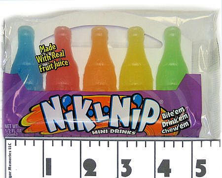
1950's - Nik-L-Nip Wax Bottles, Bubble Gum Cigarettes, Sugar Lips Wax Chewing Gum, Sen-Sen Breath Refreshments, Charms Assorted Squares, Clark Bar, Nestle's Oh Henry Candy Bar, Teaberry Gum, Slo-Poke Jr. Suckers, Candy Buttons, Gold Rocks Nugget Bubble Gum, Bubble Gum Cigars, Necco Chocolate Wafers, Skybar, Cup-o-Gold, Black Licorice Pipes, Necco Assorted Wafers, Abba-Zaba, Mary Janes, Chuckles Jelly Candy, Zagnut Bar, C. Howard Scented Gum, Walnettos, Charms Sweet Pops, and Reeds Root Beer & Butterscotch Candies.
1960's - Charms Sour Pops, Cup-O-Gold, Bubble Gum Cigar, Necco Chocolate Wafers, Clark Bar, Sen-Sen Breath Refreshments, Slo-Poke Jr. Suckers, Marshmallow Cones (Assorted Flavors), Big Hunk, Reese's Smoothie Peanut Butter Cups, Sugar Lips Wax Chewing Gum, C. Howard Violet Mints, Nestle's Oh Henry Candy Bar, Skybar, Nik-L-Nip Wax Bottles, Boston Beans, Bottlecaps, Goobers, Pixy Stix, Razzles Candy/Gum, Zotz, Necco Assorted Wafers, Candy Buttons, Bubble Gum Cigarettes, Reeds Cinnamon Candies, Black Licorice Pipe, Chocolate Cigarettes, Gold Rocks Nugget Bubble Gum, Bun Bar, Charms Assorted Squares, Cherryheads, and Teaberry Gum.
Those were the days, walk a mile to save 20 cents!
Africa Close To Home
So, how did I know about La Ballona Creek? Or as we called it, Baloney Creek!
Easy, I was born six houses away from the large concrete ditch we called Baloney Creek. I lived my first 16 years at the corner of La Cienega (The Swamp) and Venice (think waterways) on a street called Comey Avenue.
Much of the Los Angeles Basin was originally a marsh, and the inversion layer that traps smog so efficiently now, trapped moisture and warmth then. The local Indians enjoyed the water, marshlands and wildlife they brought ad the warmth.
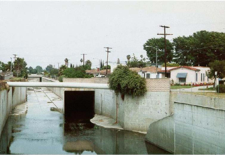
In the beginning, Ballona Creek ran placidly (usually) from the LaBrea tar pits, meandering unimpeded across the broad marshy flood plain to the ocean. The creek meandered between the Baldwin Hills and the MGM/RKO back-lot. La Ballona creek was indeed a river at one time and then over the years it became a flood control channel for LA. As houses built up, the river that drained the La Ballona watershed was changed from dirt banks to concrete reaching almost 20 feet down into the ground.
"A watershed is that area of land, a bounded hydrologic system, within which all living things are inextricably linked by their common water course and where, as humans settled, simple logic demanded that they become part of a community." - John Wesley Powell
In the 1920s, Harry Culver saw filmmaker Thomas Ince shooting one of his famous western movies "on location" on Ballona Creek, he enticed Ince to move his studio to Culver City. MGM and RKO has large sets on their Culver City back-lots.
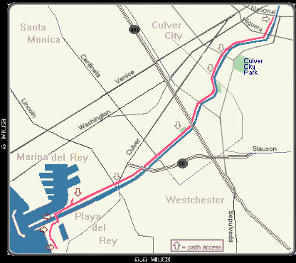
In the 1950s, about four miles of the creek lie within the City of Culver City. The rest of it is in the City of Los Angeles. For me growing up the Ballona Creek became my version of the Mississippi! Tom Sawyer had nothing on me except a lot more water.
We kids would climb down into the channel and ride our bikes are hike for miles. The creek sides were not paved and in some cases were still dirt and boulders when I was growing up. So we explored the nine miles rock by rock. I'll bet I used ten boxes of band aids after falling and nicking myself on those rocks.
Africa in Culver City California
As a kid we used to climb the hills, play in the creek, and adventure onto the back-lots. RKO Studios which not only had sound stages in Hollywood and Culver City, but had a movie ranch in Encino and a back-lot at the Culver City facility. It was at this Culver City back-lot (nicknamed Forty Acres) that he built the RKO Tarzan tree-house in a jungle area separated from the main back-lot by Ballona Creek. A lot of the jungle scenes were filmed at this site.
The creek became an African jungle because large trees grew by the side of the creek (where rocks were used to control the banks no concrete yet!). I remember seeing Tarzan's tree house from the banks of the creek! We even saw them shooting one day and had to leave at the bequest of the studio guards. I guess they did not want kids dressed as cowboys popping up in the jungle.
My creek also stared in a movie called Volcano. Tommy Lee Jones was a Los Angeles emergency official who takes charge when a volcano grows out of the La Brea Tar Pits. A river of lava flows down Wilshire Boulevard, through the uncompleted Metro Red Line subway tunnel, and creates a fountain of lava next to the Beverly Center shopping mall in Beverly Hills .In spite of placing himself and his teenage daughter in danger, Mike saves the city by diverting the river of lava into the concrete channel of Ballona Creek, which allows the lava to flow safely into the Pacific Ocean.
The flood control channel was our escape to the ocean circa 1950
Today things have changed. Ballona creek is a nine-mile-long flood control channel. it drains the ballona creek watershed, which covers approximately 130 square miles: from the santa monica mountains on the north to the baldwin hills on the south, and from the harbor freeway (110) on the east to the pacific ocean. a paved service road for county maintenance vehicles runs along the westernmost seven miles, as does a bike path.
Nothing changed here! During dry weather the creek flows with urban runoff; the water level and speed increase dramatically during storms. That runoff contains all sorts of pollutants from our air, yards, businesses, schools, and streets - trash, animal waste, oil and grease, pesticides and fertilizers, industrial chemicals. One often finds large items, such as shopping carts, which have been dumped in the creek. Algae accumulates in some places and graffiti in others. After a major storm, we saw all sorts of treasures. I'm surprised that I survived those explorations after seeing what goes into the channels today.
Aluminum Wagons
I was born with it I think. My grandfather got two of them and I ended up with one! I remember the aluminum wagon from my earliest recollections. Yup, a great big solid aluminum wagon. No Radio Flyer for me! It was a red wagon on steroids.
This thing was amazing. Over my lifetime it hauled refrigerators, mixed a ton of cement, hauled brinks, was a tank, a jeep, and almost any other thing one could imagine. I rode it up and down Comey Avenue all my childhood.
It was pulled for a 100 miles behind my various bicycles, it went down huge mountains, bounced over many a curb, and only once did it break. A break which was fixed by Brownie in 30 seconds with a new cotter pin!
The wheels where steel and hard rubber.
What a piece of work. I kept it until I was over 50 years old and gave it to a neighbor kid who needed a wagon. It was getting a little shaky and as I remember the solid steel 3/4" axels were worn thin making the wagon a little wobbly.
It sure served my childhood well and I hope it still giving to the neighbors. They since moved away and the wagon was not among the things they left behind.
Baldwin Hills Flood
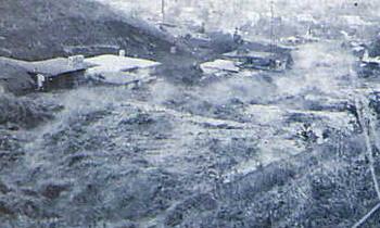
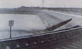
On the afternoon of December 14th, 1963, with swift suddenness, improbable tragedy struck the Baldwin Hills section of Los Angeles. Lost homes, ruined property and even death flooded downward on a broad river of rushing water from the broken dam at the head of Cloverdale Road. Automobiles, fragments of houses, and chunks of concrete were rolled and jammed like logs down the flume of the flood's path to the bottom and deposited in incongruous heaps on the ruins of Village Green, which minutes before had been a quiet Saturday-relaxed apartment community.
Mom and Dad heard the announcement on the radio and quickly calmed down the rest of the neighborhood who was ready to move. Our house was on the other side of La Ballona Flood Control Channel (Baloney Creek) so we were safe.
The flood was real but only for a few blocks
It was exciting because you must remember TV's were just starting to be used in helicopters so most of the news came form the radio and verbal descriptions. The KTLA-TV helicopter pilot and broadcaster, was flying over the flood area during almost all of the rescue operations. He personally saw and reported on much of the activity of the fire dep't. helicopter.
This earth-fill dam failed in December of 1963 releasing 65,000,000 gallons of water. It destroyed many homes and caused five deaths. Luckily, early warning and prompt action by dam personnel and the police prevented more lives from being lost. The dam was built in 1950, and during construction geologists found that two faults ran through the reservoir and the earthen dam. One of the faults was thought to be active, so special drains were constructed underneath the reservoir to allow water which might percolate through the fault to exit safely.
Amazing, the power of water
The dam was built near a large oil field, and the extraction of the oil caused the ground to subside. This caused slippage between the two faults. The slippage was minimal (only a couple of centimeters), but it was enough to rupture the lining of the reservoir. The special drains quickly clogged up with sand and water, and the 65 million gallons of water quickly cut an opening under and through the dam itself.
This dam should never have been built where it was because:
- It was in an area of known ground subsidence.
- It was close to an active fault.
- Inactive faults ran through the reservoir.
Today, we would not consider an area like this for a dam
Crossing The Viaduct

I played on this bridge for years before it was torn down for the freeway
This bridge was big and hefty looking. It was always the challenge because mom and Dad always said "do not play on the viaduct".
When I was in Junior High School, I always walked Patty Cooper home via the viaduct so I could cross the busy intersection without going on the streets. By the time I got to High School it was my way home, again a means to avoid La Cienaga and Venice, a busy and complicated inter-section.
I remember with sadness when they took it down to make way for the Santa Monica Freeway. These fine folks and their wrecking ball set up thinking it was built like the bridges of today... Wrong! The first pass revealed the bridge was solid concrete with a LOT of reinforcement. It took them nearly three weeks to take it down and a lot more energy than they had thought! It was sad to see it go!
Crystal Seaborg
Down the street from the High School was a great place to swim. I remember going there a couple of times but it was expensive, like 50 cents an hour or thereabouts!
Crystal Scarborough Swim School
2612 S Robertson Blvd, Los Angeles, CA 90034
Phone: (310)838-4088
Dry Ice?
Dry ice is an amazing phenomena
Q: Why does one feel a burning sensation when holding dry ice in his hand?
A: Dry ice (frozen carbon dioxide) is cold: -109 degrees Fahrenheit (-78 degrees Celsius). That's 109 degrees colder than most freezers, 141 degrees colder than water's freezing point, and almost as cold as Earth's coldest temperature: -129� F (89.4 C) recorded in Antarctica.
And it is true, I know, I saw it in the alley and grabbed a piece... Dropping it suddenly and yelping some choice words! When you hold dry ice in your bare hand, you freeze the tissues of your skin: progressively inward. A mere two-second exposure starts the process.
The skin contains different sensors for cold and heat, says Michel B. Ducharme, head of the human protection and performance group with Defence R&D Canada. The sensors discriminate between cold and heat only within certain bounds. Touching dry ice overwhelms the discriminatory sensors and triggers pain. Freezing is a paramount threat to the body. You feel the pain as a burning sensation.
Frostbite, like heat burns, can be a nasty injury. In fact, safety warnings liken the two injuries: "May cause severe frostbite or burns," says one about dry ice. Even mild frostbite causes cells to freeze, crystallize, rupture, and die. In cases of severe frostbite, this can involve subcutaneous tissues, muscle, tendon, and bone.
Always handle dry ice wearing protective cloth or leather gloves. An oven mitt or towel will do.
Electric Trolleys

Down Pico Blvd
We rode electric trolleys up and down Pico Boulevard for years.
As a pre-engineer I was always amazed at the wiring over the streets and the sparks and flashes made when the cars would move over junctions in the wiring!
They were quiet and moved quite nicely!
I still believe the oil companies put these guys out of business but they served their purpose for years and years!
I rode them until the late 1950's along Pico Blvd.
Gas Powered Race Car
I was lucky I guess because ad always was bringing a new toy home... His association with the dime store was great for a kid.
This one Friday, Dad brought a metal racecar with a gasoline motor... A model airplane engine! It was about a foot long, bright red, and looked great.
Saturday morning we read the instructions. It called for driving a spike in the blacktop and putting a 100 foot cable on it. Well, we had no blacktop near us except the street which was about 30 feet across.
Looked OK to us. Now I am about 9 or 10 years old and math was not something I thought about!
Dad drives the stake into the center of the street, ties the cable (still... should have been a clue) to the car, and we start the engine. This car sounds fast. It got underway and it went wild!
It was a flaming' blur as it went around and around.
Then it happened! All of a sudden the cable broke (or somehow came undone, I cannot remember) and it was loose. Damned thing shot down the street at 100 mils and hour and finally crashed into an old Studebaker belonging to Gillick!
Pieces everywhere!
The engine was still running and it kept running for another few minutes until it ran out of gas.
We laughed; we cried.
Wow! That was Saturday morning excitement at its best!
King`s Tropical Inn
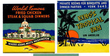
We lived a block from this famous place
Culver City was in its infancy when the Volstead Act spelled "Prohibition" in 1919. The city, incorporated just two years prior, was rapidly becoming the Heart of Screenland, with three major studios, all situated along Washington Boulevard. There were also several small studios like the architecturally distinct "Willat Studio."
Culver City was fertile ground for the entertainment of the movie crowd, and everyone else. Child-actor Fatty Arbuckle enlisted the help of studio artists to open his Plantation Cafe across the street from La Ballona School where he had been a young student. Other noted nightspots included the Casa Manana, Gladys' Hot Spot, and the King's Tropical Inn. The City boundaries were so irregular they often cut through buildings. Cash registers were equipped with wheels so that police raids could be thwarted by changing from Los Angeles to Culver City jurisdiction and vice versa.
Movies
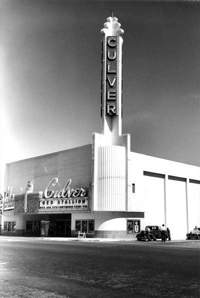
Many of my dates and I would go here for a movie
Ok... Laugh! These were scary. I was 10-12 during these movies!
But remember, the year was 1955 and these were real possibilities because science was advancing so fast! We just saw satellites become real and now Monsters from the Atomic Bombs which we created!
This is real stuff! We would go to the Thrifty Drug Store and get 4 cent candy bars bigger than ANY today and go to the movies all Saturday.... double features with cartoon for 75 cents!!!
The theater was in Culver City... we rode about 3 miles on our bikes to get there! And if we had extra money, we would sit in the loges (soft high backed seats!)
Built in 1947, as a streamlined art modern movie palace, the Culver is located near the Columbia Pictures studio lot (then the lot for MGM).
Originally, much like surrounding downtown Culver City, the Culver was a key part of classic Hollywood's thriving entertainment community.
The Culver Theatre began construction in 1945. It was built in the late Modern style, and like the Meralta, was a source of jobs for local youth. The theatre received Historic Landmark status from the city.
As the need for single theaters and ushers with flashlights declined, the Principal Theater was sold and reconfigured into a triplex.
Nike Site
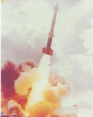
Nike bases were all over the area
In Playa Del Rey we used to bicycle to the Nike site and hope they would test fire a missile. They never did but it was an amazing site. Missiles guarding our city!
The Nike-Ajax was the first ground-based supersonic anti-aircraft missile system to become operational in the United States. The Nike missiles were deployed at sites in a circular pattern around key American industrial and military locations. The first Los Angeles area Nike-Ajax battery was emplaced in the mountains above Malibu in 1954. By 1958, there were 16 Nike-Ajax launch sites guarding the greater Los Angeles area, protecting an area of some 4,000 square miles. The Los Angeles Defense area was manned by several battalions of US Army Regulars and National Guardsman, under the command of the 47th Air Defense Brigade from 1954 to 1969.
Nike missiles were launched from a self-contained launch area. Each site was equipped with two or three launching platforms each with an underground storage magazines, an elevator and four missile erectors. The missiles were stored underground on rails and were brought to the surface by an elevator. Once on the surface, they were pushed on rails to an erector and with the proper electrical and hydraulic connections completed, raised to an angle of about 85 degrees for firing.
The Nike missiles employed the "command guidance" system in which the major control equipment was ground-based and not part of the expendable missile. The missiles were guided from a control area located at least 1000 yards from the launch area. It contained the radar equipment for acquiring and tracking the target and missile. Separate radars simultaneously located and tracked both the target and the Nike missile. Data from these radars was fed to the electronic computer which sent "commands" to the missile in flight to guide it to the target.
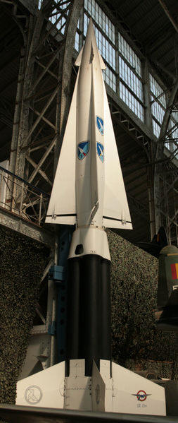
Wiked looking deterrent
The newer, more powerful Nike-Hercules missiles replaced the Nike-Ajax during the period 1958-1963. Nike-Hercules had the capability of being armed with a nuclear warhead. The Hercules was completely powered by solid fuels, eliminating the troublesome and dangerous liquid fueling procedure of the Nike-Ajax. Nike-Hercules also brought with it improved acquisition radar systems and an improved command coordinating system. The Nike Hercules were installed into modified Nike-Ajax sites in the Los Angeles area. Only 9 of the original 16 sites were converted to fire the Nike-Hercules missiles.
The Nike Hercules was designed for defense against attack by large formations of bombers. As the perceived threat changed from bomber attack to missile attack, the usefulness of the Nike Hercules diminished. On 4 February 1974, the Army ordered all existing US Nike batteries were inactivated.
LA-04 Mt. Gleason (Palmdale-Pasadena)/1954-(1959)-1974/1B, 2C/HIPAR
IFC-Located in the Angeles National Forest, 9.8 miles west of the Mill Creek Forest Station.
L&A-Located in the Angeles National Forest, 6.8 miles west of the Mill Creek Forest Station.
Both sites are currently used as correctional Facilities by Los Angeles County. The launch site magazines have been destroyed, but nearly all the other buildings remain.
LA-09 Barley Flats-Mt. Disappointment/1955-1961/1B, 2C/ACQR
IFC-Mt. Disappointment, at end of fire road L&A-Located in the Angeles National Forest, 2 miles North of Angeles Crest Highway at Barley Flats. Launch site magazines have been destroyed, the site is currently utilized by the L.A. County Sheriffs Dept. The Admin buildings remain in good shape. They were used as a probation camp until 1992. IFC site is currently used as a radio relay station, a couple of buildings and radar pads remain.
LA-14 El Monte (Whittier Narrows)/1956-1959/2B/ACQR
IFC-3600 Workman Mill Road. Located on the hill above the present Rio Hondo Police Academy.
L&A-Located at 1200/1201 Potereo Road. The Admin site is currently a U.S. Army Reserve Center. The Launch area is located across Potereo Rd in Whittier Narrows Park (west of the tennis center) and is used as a County work yard. The IFC site has been destroyed and is now a radar relay station.
LA-29 Brea (Puente Hills)/1955-(1961)-1971/1B, 2C/ABAR
IFC-Located in the Puente Hills 5 miles up Site Drive off Central Avenue. L&A-Located in the Puente Hills approximately 5 miles up Site Drive off Central Avenue. This battery had an AN/FPS-71 and an AN/FPA-16 ABAR unit. These sites are currently Shell oil fields and are largely destroyed or buried.
LA-32 Stanton (Garden Grove)/1956-(1958)-1974/2B /HIPAR
IFC-Located at the corner of Katella (Peterson?) and Knott in the city of Stanton. L&A-Located at the corner of Knott and Chapman in Garden Grove. 11751 Western Ave. This site was evidently constructed for the protection of the Los Alamitos Naval Air Station located just west of the Site LA32 complex. IFC site destroyed, L&A site used by CAARNG.
Fountain Valley/1956-1957/Temp site
IFC-Located at Santa Ana Army Air Base (now John Wayne Airport). L&A-Located at Santa Ana Army Air Base
RP-39 San Pedro Hill AFS (Z-39)/1950-1980/USAF-FAA
R-Located on San Pedro Hill off Crest Road. This was a radar site only. This was a gap filler radar for Site LA-78Cand a NORAD radar site with an AN/FPS-27 unit. It was manned by both Army personnel and USAF 670th RS unit. This site still has a number of functioning radars used by the FAA and the Weather Service.
LA-40 Long Beach Airport (Lakewood)/1958-1963/1B, 2C/ACQR
IFC-Located at the Southwest corner of Spring and Clark Street at the Long Beach Airport.
L&A-Located at the Southwest corner of the Long Beach Airport, near the intersection of Spring and Kilroy Airport Way. The IFC site has been destroyed for a hotel development. The Launch site was used for a number of years as an emergency communications facility for Long Beach city departments. It was recently destroyed during the construction of the Kilroy office complex. The Admin area remains in use by the CAARNG, but is scheduled for development.
LA-41 Long Beach (Signal Hill)/1959-1974/HQ
H-Located at 2200 Redondo Road. The site was the HHB for the 4th Brigade of the 251st ADA (CNG). Now it is used by the California Army National Guard 240th Signal Battalion, and for the Support Facilities of the 40th Division.
LA-43 Ft. MacArthur-White Point/1956-(1961)-1974/2B/HIPAR
IFC-Constructed on top of Battery Leary-Merriam on the Fort MacArthur Upper Reservation.
L&A-The facility is located directly below Battery No. 127. The Admin area was built in 1963.
The HIPAR power room with its commanding view of the Los Angeles Harbor at the IFC site, has been converted for use by the Marine Exchange. The generator and the operations control buildings are being utilized by the Angels Gate Cultural Center as artist studios. The various tower pads are in a state of general disrepair, but all are present except the HIPAR tower. The launch area at White Point is currently abandoned and sealed shut, the buildings remain but have been heavily vandalized. The administrative area was destroyed some years ago and the area developed for USAF housing.
LA-45 Fort MacArthur/1952-1974/AADCP
H-located on Pacific Ave. between 22nd St and 36th St. in San Pedro. The site contained the HQs for the Los Angeles Defense Area- the 47th ADA BDE (1952-1969), the 108th AD Group (1956-58) and later the19th ADA Group (1969-1974). It was also the site of the HHB of the 3rd battalion of the 57th ADA and after 1968, the HHB of the 1st battalion of the 56th ADA. It was the location of the area's Missile Master (AN/FSG-1), and Missile Mentor (AN/TSQ-51) command centers and was connected to the NORAD communication net which had an AN/FPS-27 (FAA) radar unit and two AN/FPS-6 radar units. The site is now owned by the USAF. The Nike Headquarters Building 550 has been demolished.
LA-55 Palos Verdes-Pt. Vicente/1956-(1958)-1974/2B/ABAR
IFC-Located at the southeast corner of Crenshaw and Seacrest Drive, Rancho Palos Verdes.
L&A-Located between Hawthorne and Palos Verdes Drive, southeast of the Rancho Palos Verdes City Hall. This battery had an AN/FPS-71 and an AN/FPA-16 ABAR radar unit. The IFC site has been destroyed and is now Del Cerro Park. The launch site is now the maintenance yard for the city of Rancho Palos Verdes and the administrative site is used as RPV City Hall.
LA-57 Torrance-Redondo Beach/1956-1963/1B, 2C/ACQR
IFC-Located at 1102 Camino Real, Redondo Beach. L&A-Located behind 25225 Crenshaw Blvd. at the east end of Torrance Airport. Launch area magazines are being used by the City of Torrance Fire Department; the all the L&A buildings have been recently destroyed. The IFC site is now Hopkins Wilderness park, few concrete structures remain.
LA-70 El Segundo-Hyperion/1956-1963/1B, 2C/ACQR
IFC-Located at West Pershing, near LAX L&A-Located at 9014 Pershing Dr., Los Angeles. There were a total of 24 launchers at this combined launch site for both LA 70 and LA 73. The Admin area is currently the home of Jet Pets at 911 So. Falmouth Ave. The Launch area and all six magazines have been destroyed. The IFC site has also been obliterated.
LA-73 Playa Del Rey-Hyperion/1956-1963/1B, 2C/ACQR
IFC-Located at Manchester and Redlands.
L&A-Located at 9014 Pershing Dr., Los Angeles.
The L&A area was co-located with LA70. The IFC site is now apartments and commercial establishments.
LA-78 Malibu (Santa Monica Mtns)/1954-(1959)-1974/1B, 2C/HIPAR
IFC-Located at 24666 W. Saddle Peak Road off Piume Rd. L&A-Located at 1900 Rambla Pacifica.
Both sites are now owned by the Dept. of the Interior. The IFC site has been extensively modified for use by various communications equipment and radars. The L&A site is currently leased by the Los Angeles County Fire Department. Most of the structures remain at the site, though they have been modified to some degree. The elevators still work on all three launch platforms.
LA-88 Chatsworth-Oak Mountain/1956-(1959)-1974/1B, 2C/HIPAR, SMFU, RRIS
IFC-Located on Oat Mountain. L&A-Located on Brown's Canyon Road. The IFC is now the site of numerous Los Angeles Country radio relay antennas and a PACTEL relay tower. The L&A site is under the control of the State of California and recently (1993) was the location of a California Conservation Corps (CCC) camp. Most of the Nike structures remain in good condition at both the IFC and L&A sites.
LA-94 Los Pinetos-Newhall/1955-(1961)-1968/1B, 2C/ABAR
IFC-Located in the Angeles National Forest off Sand Canyon Road. L&A-about 3 miles and 1 mile, respectively, from the IFC site. This battery had an AN/FPS-75 ABAR. The IFC and L sites are used by ITT Gilfillon as radar sites. The Admin site is used by LA County Fire Department.
LA-96 Van Nuys-Sepulveda/1957-(1961)-1971/1B, 2C/ABAR
IFC-Located on San Vicente Mountain next to Mulholland Dr. L&A-Located at 15990 Victory Blvd.
This battery had an AN/FPS-75 ABAR. The IFC site is partially intact in San Vicente Mountain Park, the L&A site is largely intact and is used by the California Air National Guard. A section of the launch area is used by the Army National Guard.
LA-98 Magic Mountain-Lang (Saugus)/1955-1963/1B, 2C/ACQR
IFC-Located in the Angeles National Forest on top of Magic Mountain. L&A-Located south of State Highway 14 in Soledad Canyon (Lang Station). Though the battery was closed by 1963, the Admin area was used till the early 1970s. IFC site is now used as microwave relay. The L&A site is being used by a cement company and may be extensively modified.
Pasadena Army Support Center/1950-1963/HQ
H-located at 125 S. Grand Ave. in Pasadena. This site was the HQ for the 12th Artillery Group and the HHB of the 1st Battalion of the 56th ADA from 1956 to 1963. It is now a federal court building. The structures used for some of the Nike functions were located on the hillside behind the courthouse proper.
On The Set
Brownie, our next door neighbor would often take us to the set of the latest movie or sitcom. He was a cameraman at MGM abd had access to the lots anytime he wanted!
Printer In The Little Red Building
At the corner of La Cienega and Venice used to be a small red shop about the size of a garage and inside was a printer who would make magic. At the end of a run, he would throw out the remaining paper and I would be there to pick up anything useful. I had tons of paper of all sizes and colors after months of rummaging through hi trash cans every night.
Red Cars

We woud take these to the beach or downtown LA
When I grew up we had rapid transportation and it was NOT in subways, it was red cars!
In the 20�s as Los Angeles was becoming more and more populated, the "Red Cars" were born. They reached their peak in popularity in the 1920s, then slowly fell victim to Angelinos� love of their automobiles. Freeways did them in along with the auto and gas companies.
By the time the last Red Car was retired from service in 1961, no body cared. Sure wish we had kept them! Visit the USC history archives site that discusses the "Red Cars".
I remember them quite well... from Los Angeles to Long Beach in 40 minutes... better time than we make today! They ran on a regular schedule and made it easy to move long distances.
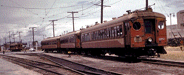
They moved right along at high speed
Read about the Red Cars on the websites of the ...Electric Railway Historical Association or the USC Historical Information. The picture below was typical in the 1940s and 1950s. The car ran along major boulevards and were electric... No pollution!
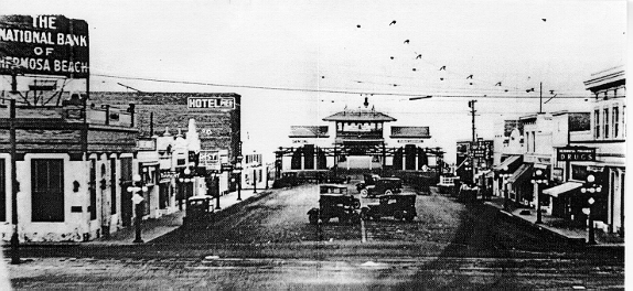
Below is a picture of a red car cross over the intersection of Venice and La Cienaga about 6 doors from where I lived on Comey Avenue! Mom and dad called the concrete bridge ovr the intersection a viaduct ("A series of spans or arches used to carry a road or railroad over a wide valley or over other roads or railroads"). Dad would always ask Via Duck? I think it was a play on the Marx Brothers. As a kid I could see the trains go by as they would slow coming up the hill and speed going down the hill towards downtown Los Angeles.
This picture was 40 feet above La Cienega and Venice in Los Angeles
I remember the day the viaduct was being removed by the freeway builders. They brought in a big wrecking ball.
We could go to Redondo Beach on the Red Car Line
The scene above is from the early 1920s. You might note the electric lines at the top of the photo that provided power to the Pacific Electric train, or "Red Cars," that ran along the beach from Los Angeles to Redondo Beach. The red car system, built in the early years of the 20th Century, provided an extensive network of electric trolley lines which served the Los Angeles area well, even though the ride was often bumpy. The tracks ran along Hermosa Avenue in Hermosa Beach and were briefly uncovered during a recent sewer construction project. The trolleys became a victim of the freeway system, which was proclaimed the wave of the future at its inception. Today, many of us sadly lament the passing of the old red cars, especially when we see the costs associated with the slowly emerging new electric trains.
Self-Serve Was The Name Of The Game
Drive Ins were all over the place; the car was king!
Modern times were here. It was the 1950s and all was well. The latest craze, a drive-in restaurant without the waitresses (car hops).
We went to the "Clock Drive In" in Culver City at least twice a week.
The car hops were pretty great and some even had skates.
How they managed a tray full of food, fastening it to the car, and all the other tings they did was always amazing to me.
But alas, technology changes everything. Now werehaving robot food service.
When you drove up and parked, a machine on a long track would be sent to your car where you would pick up the menu.
You would make your selections and then speak into the microphone. A voice would record you order and then you would wait a few minutes.

Drive ins were very popular
A few minutes later, there would be a metal container come down the track containing all the food you wanted on a tray that was automatically adjusted to the height of your car! When you were done, the remainders were put back into the little machine and it would go back and bring our dessert and the bill.
You put money into the machine and drove off... never seeing a car hop!
This place was on La Cienega blvd between Pico and Venice about 1953 and it lasted about a year before the car hops were back!
Ten For A Dollar Tacos At Foster's Freeze In Culver City!

Very popular in the 1950's
In those days, we could go out on Saturday and get ten tacos for a dollar! What a deal! They were not small ones either!
The Taco is a traditional Mexican dish composed of a rolled, folded, pliable maize or wheat tortilla that can be filled with a wide variety of edible substances.
The fact that a taco can be filled with practically any meat, vegetable, and cheese allows for great versatility and variety.
A taco is generally eaten out of hand, without the aid of utensils, and is often accompanied by a garnish such as salsa and vegetables such as cilantro, onion, cabbage, tomato, or lettuce.
Skating At The Rink
Family was important to Harry Culver. The Rollerdrome was a perfect example of how Culver wanted to provide for Culver City parents and their children. Today that site is Tellefson Park, a bicentennial dedication in 1976.

Saturday and Sunday for years I was there like clockwork
People came from miles around to skate at the Rollerdrome. It was a wooden structure with a gently rounded parabola-like roofline. The height offered by this curve accommodated a mezzanine in the front of the building, where the organist played.
Many remember the building filled with cheery roller skating music. Then there was the bell, and "Clear the Floor," to prepare for a variety of skating opportunities like "Ladies Only."
We would go Saturday and Sunday afternoons and skate until late afternoon. Skating would start again around 8:00 and go until 11:00 or so.
I remember buying my first set of "professional skates". They were black and shiny and had the greatest brakes, just like the instructors who roamed the floor.
Sneaking Into The Loges
Kids will not remember loges in theaters but in my day, we had a special place in the theater where the seats were more comfortable. All seats were high-backed leather loges that one found in the loge sections of major theatres in the area - very comfortable. Theater seats at the rear of the main floor of older movie theaters that have wider, softer, and more widely spaced seats, sometimes capable of rocking and often with a greater height difference between rows. Patrons using these seats were usually charged a higher ticket price than the general admission.
Our theater was in Culver City and it was a beauty in the late 30's and early 50's,
But they were a lot of money, maybe an extra 25 cents so we would sneak into the loges and of course the theater attendant would herd us back out again.
Dictionary.com defines loge as :
- A small compartment, especially a box in a theater.
- The front rows of the mezzanine in a theater.
Swinging On The Bridge
Rope was always my favorite things growing up! You could do so much with it! At the end of our street. Comey Avenue, was La Ballona Flood Control Channel (aka Baloney Creek).
Behind our house was La Cienaga which was a major street in Los Angeles and it crossed La Ballona Creek with a perfectly nice bridge suitable for swinging!
One afternoon, I walked half-way over the bridge, looked for cars hoping no drivers would see what I was up to. I tied a rope to the railing, threw the rope over the side and proceeded to climb down the rope about 60 feet which was a few feet above the "water".
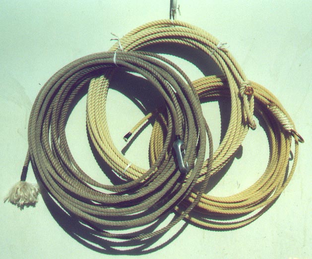
Rop was my favorite toy!
The rope came from the construction crew that was digging a drainage ditch behind our home. Every evening I would go out an look to see what they left behind form that day. I got about 400 feet of one inch rope, strong enough for anything!
You guessed it, I swung on that rope for weeks moving from one side of the Baloney Creek to the other. I was probably 12 or 13 when this occurred. Until my mother came to live with us, I thought she never knew.
One evening Mom told Sue of my exploits with rope and the bridge adventure. She told Sue that she knew but wanted me to learn to be a boy so she did not stop me. She did repeat that she did hope that I would not let go!
I do remember why I stopped other than rope had a lot of purposes and I probably moved on!
I do remember on one swing I grabbed the rope too from the top of the bridge. When I attempted the swing from one side of the creek to the other, which was bout 40 feet, I learned quickly that I should have grabbed a higher point on the rope.
I did the Tarzan thing and hit the bottom of the cement creek landing in the wet oozy stuff crud which had the consistency of wet clay. Yuck!
When the day of swinging was done, the rope came down, I carefully coiled it up, stored away and I snuck in the back door and took the worlds longest shower!
Tar On The Feet
As a child I lived in Culver City and the beach was just a short ride away. We always went to Venice or Playa Del Rey but when we went, there were oil wells lining the highway. When these puppies blew, it coated the sand with tar. Walking of Venice or Playa Del Rey beaches meant your feet (or shoes) would be nearly black with tar.
The heavy tar came off fairly easily but the tar left a stain on the feet and one would never get into a car (specially a new car) without putting a towel on the floorboard so the tar would not get in the carpeting.
The tar was clear out into the water and it sunk so walking in the water was not a method that would guarantee your feet would not become black!
Making The Beach At Playa Del Rey By Pumping Sand From The Ocean
Playa del Rey sits just above sea level, beneath the Westchester bluffs on a flood plain (until 1824, the mouth of L.A. River) which slopes gradually uphill north to the Santa Monica Mountains. The rolling hills are the result of ancient, wind-blown, compacted sand dunes which rise up to 125 feet above sea level, with one prominent, steep dune running parallel to the coast, Playa del Rey, all the way south to Palos Verdes.
The community is bordered by the Pacific Ocean to the west, Marina del Rey and Ballona Creek to the north, Playa Vista to the northeast, Westchester to the east, and El Segundo to the south.
Mom and Dad told me that in the late 40's they would come to the beach and watch the beach being made. Apparently the beach was very narrow and for a period of a year or so, ugh dredges pumped sand from out in the ocean to the shore and the beaches of Venice and Playa Del Rey were built up from nearly nothing.
I remember this picture but 40 years later. The hill in the center used to be the one I made Mom and Dad go up and down on when we went to the beach!
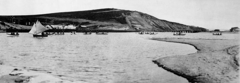
We used to drive up and down the hills in our 1947 chevy
Treasures In The Alley
Behind the Comey Avenue house was an alley that had many businesses backed up on it. An alley or alleyway is a narrow, pedestrian lane found in urban areas which usually run between or behind buildings. In the United Kingdom an alley may be a right of way or ancient footpath in an urban setting. In older cities and towns in Europe, alleys are often what is left of a medieval street network, or a right of way or ancient footpath in an urban setting. In older urban development, alleys were built to allow for deliveries such as coal to the rear of houses. Alleys may be paved, or simply dirt tracks. Blind alleys have no outlet at one end and are thus a cul-de-sac.These companies provided immeasurable happiness for me by supplying endless kid-required resources by filling their trash. Dad used to tell me not to move their trash into our backyard. Dad was smart so he really knew these were treasures.
In order of business/store, I often got treasures including:
- Heating/Plumbing Store - Large paste-board cartons, wooden packaging, insulation, pipe, ducting
- Furniture Repair - Irreparable furniture, wood, doweling, partially used containers of paint and glue and stains
- Cabinet Maker - Wood, old cabinets, cabinet doors, sawdust, almost empty boxes of screws/nails, molding
- Pen Manufacturer - Lindy ball point pens were made directly behind us. I always had the world supply of pens but often had to get them started with a small amount of heat.
- Furniture Delivery Service (California Delivery Service) - Rope, tie downs, boxes, containers
- Meat Market - No, not meat! But plenty of DRY ICE! Occasional freezers, refrigerators
- Gas Station (Flying "A" - Tires, grease, oil cans, car parts
- Printer - Paper, paper and more paper!
Walking The Tunnel
A huge flood control channel ran under our back yard. In fact, it was the channel that the volcanic eruption from the movie Volcano was send through! Volcano is a 1997 disaster action film starring Tommy Lee Jones, Anne Heche, and Don Cheadle. It was directed by Mick Jackson, and was released in the United States on April 25, 1997, just months after the release of Dante's Peak, another film about a volcano acclaimed as being more scientifically accurate. As a kid, we would often open the man hole cover and go down into this massive tunnel and walk for an hour always hoping that a gush of water didn't come surging through the tunnel and wash us away!
The movie: Tommy Lee Jones stars as Mike Roark, a divorced Los Angeles emergency official who takes charge when a volcano grows out of the La Brea Tar Pits. A river of lava flows down Wilshire Boulevard, through the Metro Red Line subway tunnel, and creates a fountain of lava next to the Beverly Center shopping mall in Beverly Hills. The lava destroys one subway train in the Red Line, kills the Metro chairman by melting him while saving the driver of the car, burns cars, firemen, homes, and fire trucks, and burns down the Los Angeles County Museum of Art. To stop the flow of lava, he plans to use 82 concrete structures used on freeways to create a cul-de-sac, and pool up the lava. They then use all their water to put out the lava with the help of helicopters dumping gallons of water on the lava. After the lava has cooled down, the geologist goes down into the subway Redline area and finds out their is still more lava waiting to blow.
In spite of placing himself and his teenage daughter in danger, Mike decides to save the city by diverting the river of lava (with the help of demolition teams) into the concrete channel of Ballona Creek, which allows the lava to flow safely into the Pacific Ocean.
Wooden Oil Derricks Dotted Playa Del Rey And Venice Beaches!
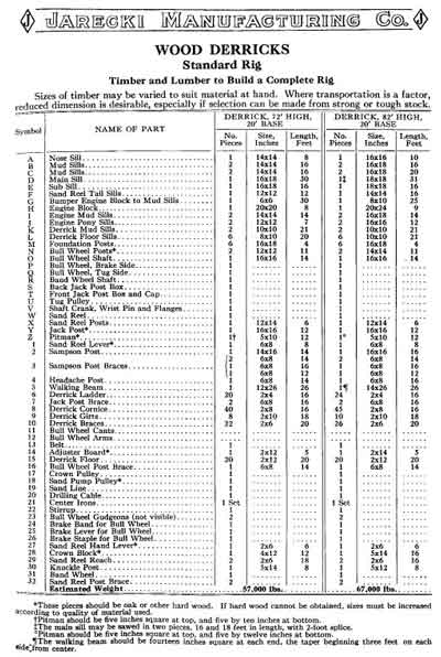 We grew up going to Venice Beach and I can remember laying on the sand looking up into the sky seeing the large wooden oil derricks in the sky. So, what is a derrick?
- A machine for hoisting and moving heavy objects, consisting of a movable boom equipped with cables and pulleys and connected to the base of an upright stationary beam.
- A tall framework over a drilled hole, especially an oil well, used to support boring equipment or hoist and lower lengths of pipe.
These were remarkable works having huge 14 x 14 pieces of wood at the bottom and going up into the sky.
Now I always though they were 200 feet tall but of course in those days I was only three feet tall.
According to history, the standard Walking Beam oil derrick has either 72 or 82 feet tall.
I can remember the huge walking beams (the teeter-totter) that was driven up and down in order to pump oil from the ground.
These derricks weighed in at 67,000 pounds and I always worried one would fall down. Never did and probably never would if it was maintained properly.
The walking beam was the huge piece of wood that connected the rotary engine to the pump rods. It rocked back and forth 24x7 and made a not unpleasant noise as it worked to extract the oil from far below the beach.
There were so many of these old rigs, it was no wonder that we had to take the tar off our feed before we got into the car in the 1950's. T
There was tar (super thick oil) in the sand all along the beach from Playa Del Rey through to Santa Monica because of the wells.