Cruising Prince Williams Sound (June 16th)

Prince William Sound is a sound off the Gulf of Alaska on the south coast of the U.S. state of Alaska. It is located on the east side of the Kenai Peninsula. Its largest port is Valdez, at the southern terminus of the Trans-Alaska Pipeline System. Other settlements on the sound, which contains numerous small islands, include Cordova and Whittier plus the Alaska native villages of Chenega and Tatitlek.
Most of the land surrounding Prince William Sound is part of the Chugach National Forest, the second largest national forest in the U.S. Prince William Sound is ringed by the steep and glaciated Chugach Mountains. The coastline is convoluted, with many islands and fjords, several of which contain tidewater glaciers. The principal barrier islands forming the sound are Montague Island, Hinchinbrook Island, and Hawkins Island.
James Cook entered Prince William Sound in 1778 and named it Sandwich Sound, after his patron the Earl of Sandwich. The editors of Cook's maps changed the name to Prince William Sound, in honor of Prince William, who would later become King William IV.
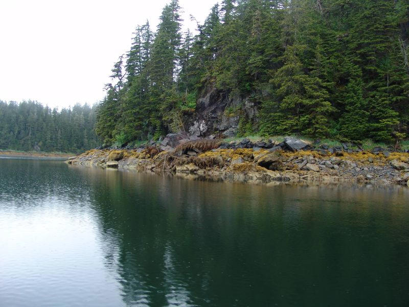
The area is still wild and non-developed
Prince William Sound with its 3,000 miles of shoreline is surrounded by the Chugach Mountains to the east, west and north.
Fifty-mile long Montague Island and several smaller islands form natural breakwaters between the Sound and the Gulf of Alaska. Between the barrier islands stretch underwater sills separating the Sound's deep waters from the much shallower waters of the Gulf.
Deep water renewal occurs during the winter when cold winds from interior Alaska cool the surface waters causing them to sink, while the warmer bottom water rises to the surface bringing rich nutrients which support huge plankton blooms in the spring.
The Scenery Was Fantastic!


Did You Know? - Prince William Sound with its 3,000 miles of shoreline is surrounded by the Chugach Mountains to the east, west and north. Fifty-mile long Montague Island and several smaller islands form natural breakwaters between the Sound and the Gulf of Alaska. Between the barrier islands stretch underwater sills separating the Sound's deep waters from the much shallower waters of the Gulf. Deep water renewal occurs during the winter when cold winds from interior Alaska cool the surface waters causing them to sink, while the warmer bottom water rises to the surface bringing rich nutrients which support huge plankton blooms in the spring.
Millions of years of glaciation gradually carved away a coastal plateau creating the sound with its many tributary fiords and passageways, islands and rocky shores. Fewer than 10,000 people live in the three towns-Whittier, Valdez, and Cordova- and two native villages-Chenega and Tatitlek situated on the shores of the Sound. Because the Sound was formed by millions of years of glaciation, its shorelines are heavily indented by deep fiords and many smaller bays. No roads connect these communities.

 Blue ice, we need a cocktail!
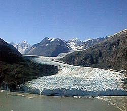
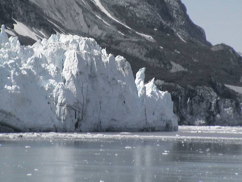
The Columbia Glacier is a glacier in Prince William Sound on the south coast of the U.S. state of Alaska. It is one of several glaciers in the area named for elite U.S. colleges, in this case Columbia University, and was named by the Harriman Alaska Expedition in 1899. It is one of the fastest moving glaciers in the world, and has been retreating since the early 1980s.
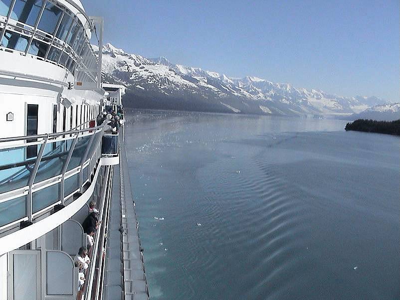
Now we exit Prince William Sound and enter Glacier Bay .
Glacier Bay (June 17th)


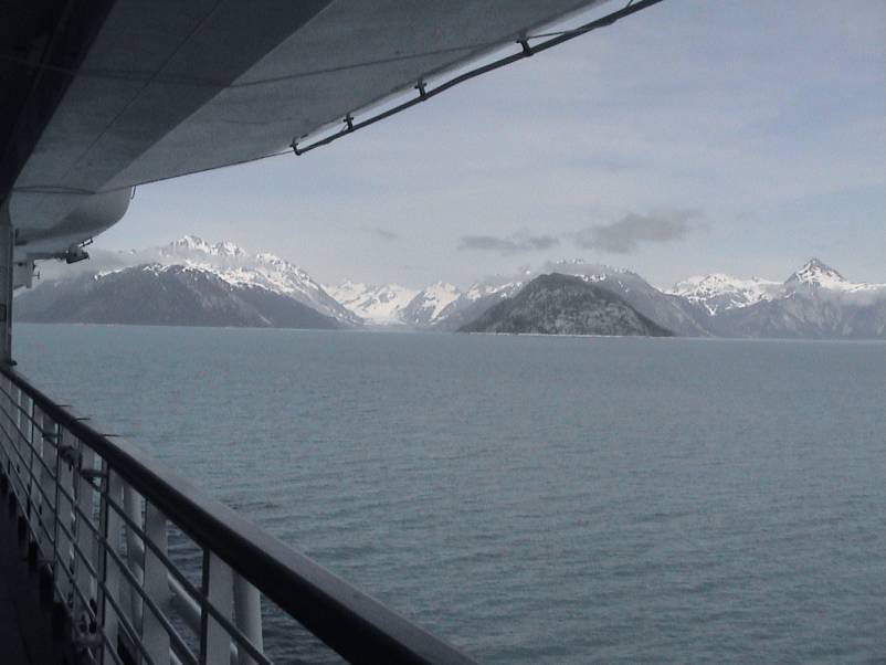
Between 58 and 60 degrees north latitude, is the Glacier Bay region, the margin of North America is thrown into a broad arc of rugged mountain ranges that intermingles with the Pacific is a maze of ice-scoured fjords, valleys, beaches, straits and islands, the whole comprising an amphibious landscape where no point of land or sea is more than 30 miles from a shore.
It is an austere place of big tides, strong currents, fall gales and frequent earthquakes, a landscape of great peaks hard against profound depths, of somber blues, greens and grays only occasionally relieved by the pastels of a grassy meadow or sunset sky.
Though perhaps one quarter of the region remains under ice today, glaciers were much more extensive just two centuries ago, and during the last Great Ice Age coalesced into an all-pervasive plateau having the aspect of modern-day Greenland.

As you enter Glacier Bay in Southeast Alaska we cruised along shorelines completely covered by ice just 200 years ago. Explorer Captain George Vancouver found Icy Strait choked with ice in 1794, and Glacier Bay was barely an indented glacier.
That glacier was more than 4000 ft. thick, up to 20 miles or more wide, and extended more than 100 miles to the St. Elias Range of mountains.
By 1879 naturist John Muir found that the ice had retreated 48 miles up the bay. By 1916 the Grand Pacific Glacier headed Tarr inlet 65 miles from Glacier Bay's mouth.
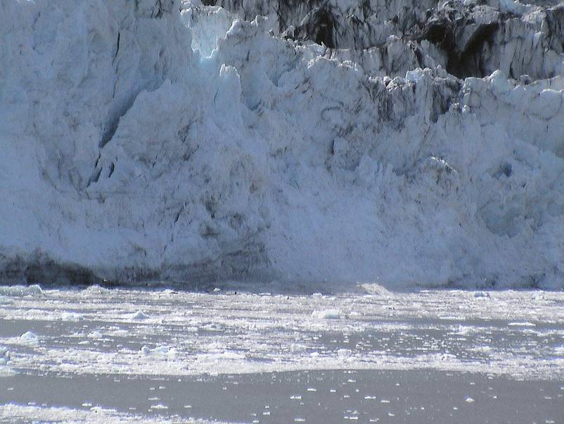
We spent two days in glacier bays... fantastic sights... some of the glaciers being 5 miles wide and 200-800 miles in length! The "dirt" on the surface is ground-up bed rock which the glacier cuts into while traversing the canyon!
Photos From The Ship


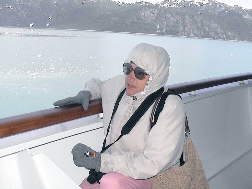
Perhaps a tad chilly outside on the deck! Duh!
Did You Know? - Glacier Bay Basin in southeastern Alaska, United States, encompasses the Glacier Bay and surrounding mountains and glaciers, which was first proclaimed a U.S. National Monument on February 25, 1925 and which was later, on Dec. 2, 1980, enlarged and designated as the Glacier Bay National Park and Preserve under the Alaska National Interest Lands Conservation Act, covering an area of 3,283,000 acres.
Barely moving
Did You Know? - Glacier Bay, the body of water, covers an area 1,375 square miles (3,560 km2) of glaciers and accounts for 27% of the Park area. It was a large single glacier of solid ice till early 18th century. It started retreating and evolved over the centuries into the largest protected water area park in the world. Glacier Bay, on the Gulf of Alaska, was known as the Grand Pacific Glacier about 4,000 feet (1,200 m) thick and about 20 miles (32 km) in width which has since then, over the last more than 200 years retreated by 65 miles (105 km) to the head of the bay at Tarr Inlet, and in this process left separate 20 other glaciers in its trail. In 1890, the name "Glacier Bay" as such was given to the bay by Captain Lester A. Beardslee of the U.S. Navy. It was first proclaimed a U.S. National Monument on February 25, 1925 by President Calvin Coolidge.

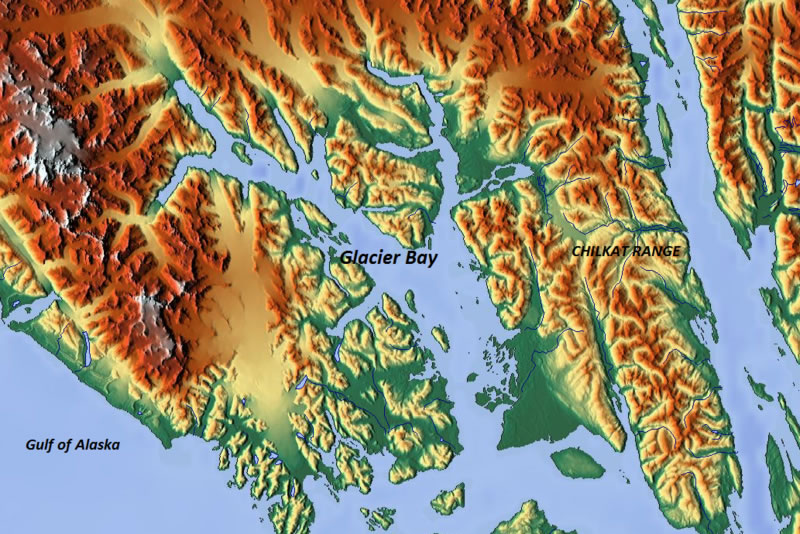
Satellite view of Glacier Bay

Tobasco kept Zack moving in the cold weather
B-r-r-r-r-r-r-r-r-r


Did You Know? - Geologists believe that Glacier Bay existed during a minimum of four Glacial periods ending with the Little Ice Age, which has a 4,000 years old record, as the latest period. All glaciers in the park today are said to be remnants of this glacial period.
The earliest recorded history of the Glacier Bay area starts with the 1741 Russian expedition of Vitus Bering and Aleksei Chirikov. La Perouse (after whom one of the glaciers in the bay was named subsequently) established contact with the local inhabitants, the Tlingits at Lutya Bay, in 1786. This was followed by the Russians staking their claim to the region.

Did You Know? - When President Calvin Coolidge declared the Glacial Bay to be a national monument, in 1925, the objective clearly stated was:
"a number of tidewater glaciers ... in a magnificent setting of lofty peaks ...; a great variety of forest covering consisting of mature areas, bodies of youthful trees which have become established since the retreat of the ice which should be preserved in absolutely natural condition, and great stretches now bare that will become forested in the course of the next century; a unique opportunity for the scientific study of glacial behavior and of resulting movements and developments of flora and fauna and of certain valuable relics of interglacial forests; historic interest, having been visited by explorers and scientists since the early voyages of Vancouver in 1794 who left valuable records of such visits and explorations."


Hitching a ride
Did You Know? - A glacier (pronounced UK: /ˈɡlæsiər/ glass-ee-ər or US: /ˈɡleɪʃər/ glay-shər) is a large persistent body of ice. Originating on land, a glacier flows slowly due to stresses induced by its weight. The crevasses and other distinguishing features of a glacier are due to its flow. Another consequence of glacier flow is the transport of rock and debris abraded from its substrate and resultant landforms like cirques and moraines. A glacier forms in a location where the accumulation of snow and sleet exceeds the amount of snow that melts. Over many years, often decades or centuries, a glacier will eventually form as the snow compacts and turns to ice. A glacier is distinct from sea ice and lake ice that form on the surface of bodies of water.
The word glacier comes from French. It is derived from the Vulgar Latin *glacia and ultimately from Latin glacies meaning ice.[1] The processes and features caused by glaciers and related to them are referred to as glacial. The process of glacier establishment, growth and flow is called glaciation. The corresponding area of study is called glaciology. Glaciers are important components of the global cryosphere.
On Earth, 99% of glacial ice is contained within vast ice sheets in the polar regions, but glaciers may be found in mountain ranges of every continent except Australia.


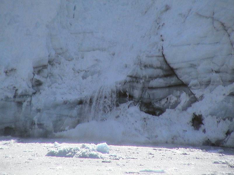
Did You Know? - Tidewater glaciers are glaciers that terminate in the sea. As the ice reaches the sea pieces break off, or calve, forming icebergs. Most tidewater glaciers calve above sea level, which often results in a tremendous splash as the iceberg strikes the water. If the water is deep, glaciers can calve underwater, causing the iceberg to suddenly leap up out of the water.
The Hubbard Glacier is the longest tidewater glacier in Alaska and has a calving face over 10 km (6 mi) long. Yakutat Bay and Glacier Bay are both popular with cruise ship passengers because of the huge glaciers descending hundreds of feet to the water. This glacier type undergoes centuries-long cycles of advance and retreat that are much less affected by the climate changes currently causing the retreat of most other glaciers. Most tidewater glaciers are outlet glaciers of ice caps and ice fields.


Did You Know? - Glaciers move, or flow, downhill due to the internal deformation of ice and gravity. Ice behaves like an easily breaking solid until its thickness exceeds about 50 meters (160 ft). The pressure on ice deeper than that depth causes plastic flow. At the molecular level, ice consists of stacked layers of molecules with relatively weak bonds between the layers. When the stress of the layer above exceeds the inter-layer binding strength, it moves faster than the layer below.
Let go where it is warmer